Wild camping in Oman (Pt. 2)
“السلام عليكم (as-salām ʿalaykum) — ‘Peace be upon you!’”
By my second week in Oman, this common greeting was one of two phrases I had learned to say regularly. The other word, pronounced “shukraan”, means “thank you”. If you’re in Oman, you really have to learn to say “thank you” in Arabic, because Omani people will always be offering you their selfless assistance and hospitality!
The post describing my preparation and first week in Oman you can read here
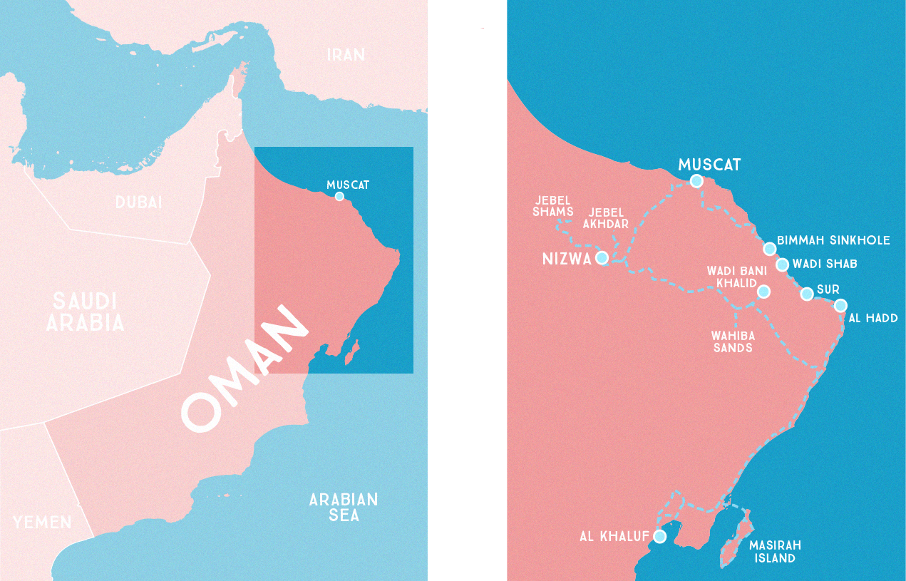
Wadi Bani Khalid وِلَايَـة وَادِي بَـنِي خَـالِـد

So after having been to two wadis (swimming holes) in Oman, I sort of wondered if it would be redundant to visit another. We decided to go anyway, and I sooon learned that THERE IS NO SUCH THING AS VISITING TOO MANY WADIS! Not only are wadis these paradisiacal oases, but each one is a completely unique experience. A wadi is a canyon or valley with a river running through it, but each of these places is entirely different, depending on the geology and how people have developed the region. Wadi Bani Khalid was the most open wadi we visited— with a magnificently wide, emerald-green pool, and beyond it a narrow canyon with tucked away swimming areas, and even a bat cave that you can climb into if you venture far enough into the rocks.
Oman is a Muslim country, but their attitude about things like women’s dress is (so I hear) more relaxed than some other Muslim places. As a tourist, it is acceptable to have your hair uncovered, and to wear short sleeved shirts, and when I was around the beach I didn’t feel disrespectful wearing shorts. At some wadis you will see signs saying that “modest” swimwear is required, and that women should not be exposing their shoulders and mid-riffs. Wadi Bani Khalid was the only place where I experienced this dress code enforced, and the lifeguards asked me to put on more clothes over my one-piece swimsuit (“your shirt is too short”). He said that I could go further into the canyon to the “tourist area” (where I saw western tourists sunbathing in bikinis), but I simply put on a t-shirt over my swimsuit and continued cliff-jumping from the rocks in the main pool.


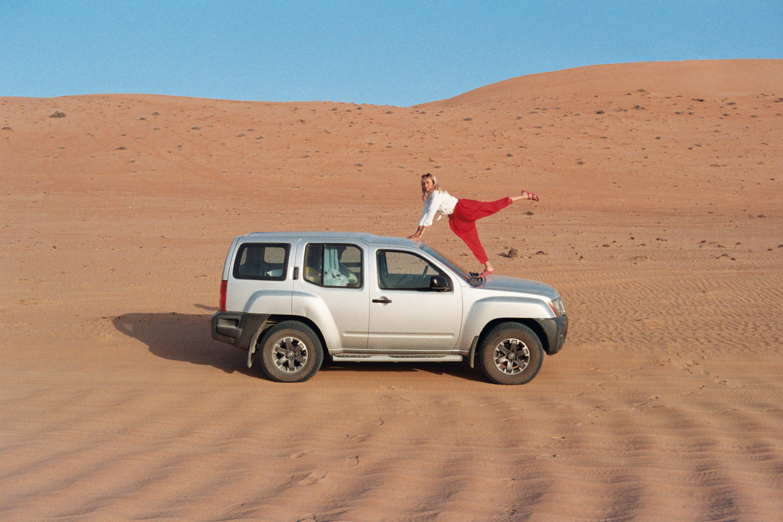
Wahiba Sands ٱلرِّمَال ٱلشَّرْقِيَّة
Sharqiya Sands, also known as Wahiba Sands is what you think of when you imagine Arabia. The Sands are an expanse of red-orange sand dunes, 50 miles wide and 110 miles long. You can camp at one of many budget or luxury “desert camps” in this region, but David and I wanted to keep “wild” camping since we had all of our own gear to do so.
I had never driven very far on sand dunes before, but it proved to be easy enough when we stuck to the “roads”, which were nothing more than tire marks from regular traffic through the dunes. At the end of the town and beginning of the dunes, we needed to release some air from the tires of our 4-wheel-drive car, to help keep traction in the sand. We had no idea what the ideal pressure was for driving on sand, but it only took 2 minutes of standing around and looking puzzled, before a local man and and his family stopped to do it for us (Omani people are the best). Driving on the dunes was so much fun, I definitely tested the limits of our Nissan Xterra and nearly got us stuck in deep and steep sand.
We attempted to set up camp on the very top of a steep sand dune, but at sunset wind picked up and sent the tent flying like a kite into the air and down the side of the hill. We instead set up camp in the valley, where we enjoyed a campfire and our last ration of beer from the airport duty-free. In the morning we awoke to a moody blanket of fog hanging in the corner of the valley, which slowly melted away with the rising sun.


Jebel Akhdar
Jebel Akhdar, also know as “the Green Mountains” is a mountainous region in Oman. The average elevation in the region is 4000ft (1220 m), with the highest point reaching just under 10,000 ft (2,980 m). Here the temperatures are much more mild than the rest of Oman, and for the first time on the trip, I needed to wear a light jacket at night.
The road to Jebel Akhdar was winding, and in some places very steep. I would have found the drive to be nerve-wracking, had I not driven the much steeper and narrower road to Wadi Tiwi the week before. For one night we were the only guests at an Airbnb located in a very old little stone village that had been built in a hillside.


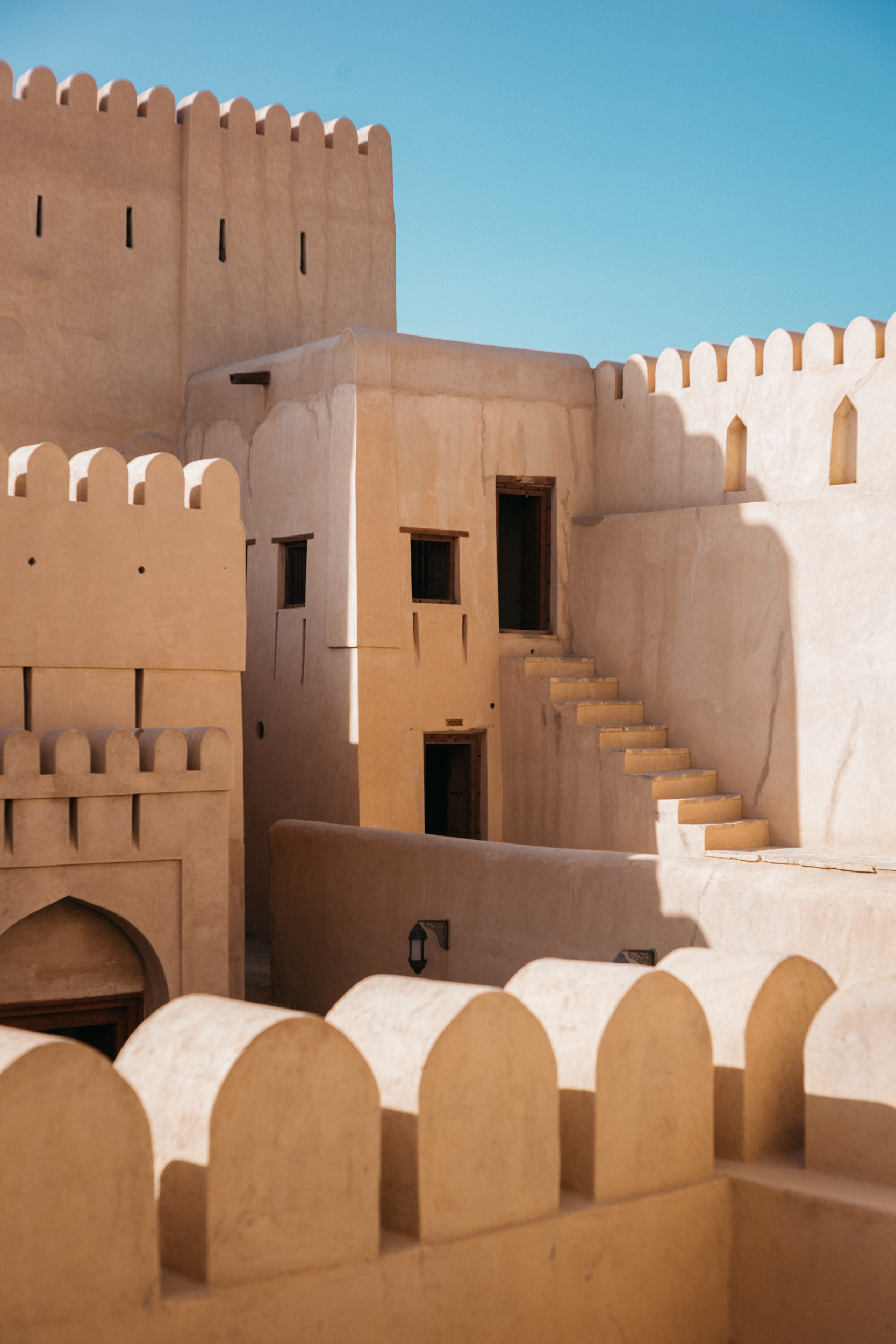
NIZWA نِزْوَى
Nizwa is the third largest city in Oman. We planned our roadtrip to pass through Nizwa so that we could visit the Goat Market , a cultural experience that we were told is not to be missed. On Friday mornings at sunrise, a livestock market takes place at the Nizwa Souq, the city’s open-air marketplace.
While in Nizwa we also toured the city’s famous fort, a 400-year old fortress which is a photographer’s dream.


Jebel Shams جَبَل شَمْس
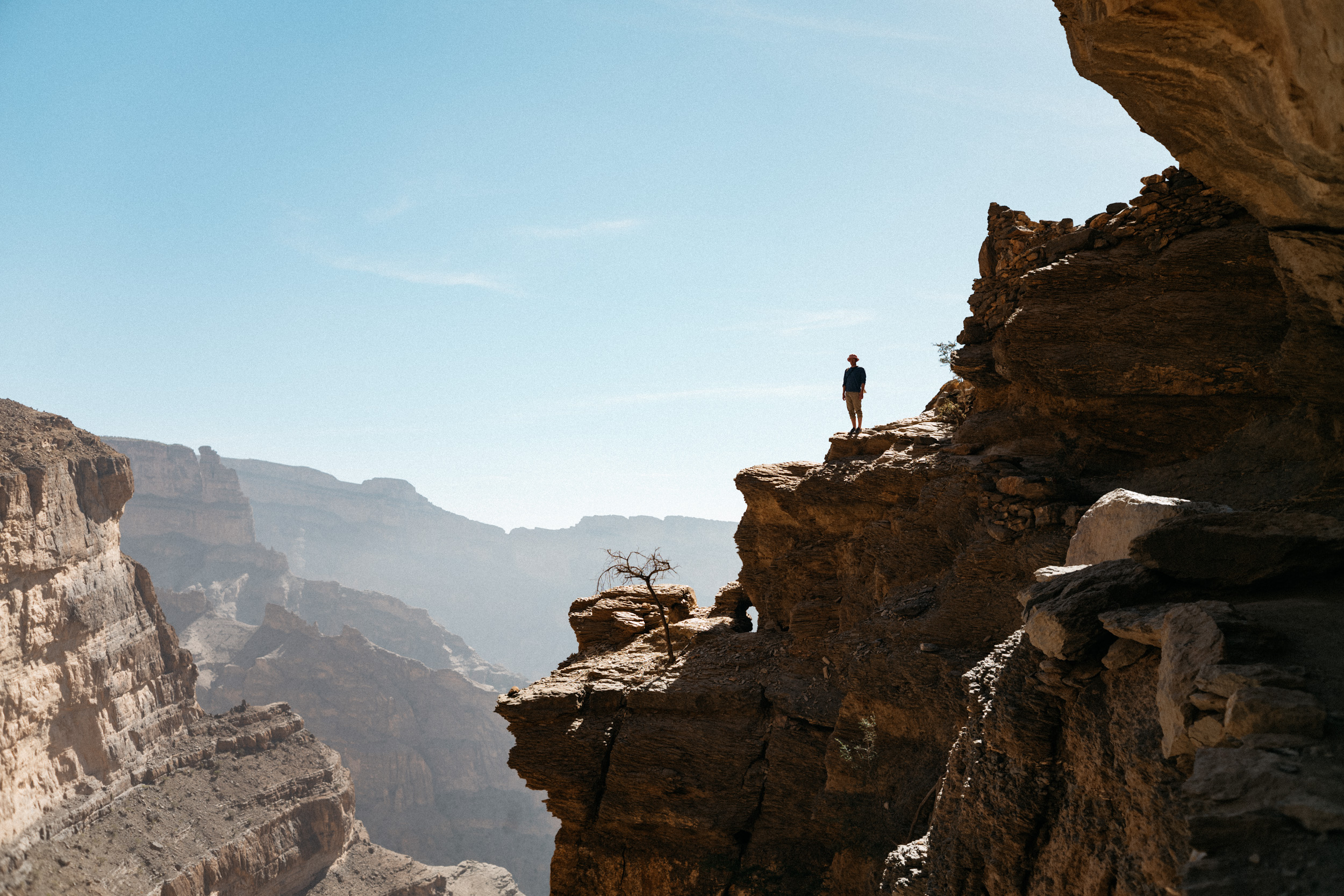
Within the region of Jebel Shams ('mountain of the sun') is the Grand Canyon of Oman. Imagine the Grand Canyon, only slightly smaller scale, with brown rock… and there are GOATS everywhere. This haven of goats was our last destination on our Oman roadtrip. Here we camped on the rim, overlooking the canyon, and in the morning we hiked the balcony trail to an abandoned cliffside village. Like Jebel Akhdar, Shams is located at high elevation, with the tallest point being at 9,987 feet. Here, we set up camp as close to the cliffside as we possibly (and safely) could. As we were setting up camp, we were interrupted by a herd of sneaky goats, which were helping themselves to the contents of our open trunk. It is not okay to feed wildlife, but I don’t think that goats actually qualify as wildlife… so I offered them carrots and leftover Dominos Pizza potato wedges (which they went crazy for… the carrots; not so much).


Balcony Walk
We only did one hike in Oman, the Balcony Walk down into the canyon at Jebel Shams. This moderately easy 5-mile roundtrip hike takes you along the edge of the canyon to a little abandoned cliffside village called Khateem/Khatayam. Here, there are remnants of terraced gardens and dwellings built into the side of the cliff, with a thousand-or-more-foot shear drop below (I threw a rock into the canyon and counted exactly 10 seconds for it to hit bottom). I don’t know when the village was last inhabited by anyone but goats, but it looks quite old and like somewhere out of Indiana Jones. I would be very curious to know about how the village was built and about the lives of its former inhabitants.