We summited 14,505’ Mt. Whitney!!!
“…I summited Mt. Whitney!!! This was an enormous accomplishment for me, who for my whole life up until a few years ago DID NOT hike. I’ve put in a lot of miles since then, determined to overcome my inability to walk up any amount of incline without stopping every minute to gasp for air 😰”

Me and Jason the moment we reached the summit, captured by Mark Popovich.
I’ve wanted to hike Mt. Whitney for years, but I never thought I would or could actually do it. First off, it’s hard as hell. Second off, getting a permit to hike Mt. Whitney is also very hard (my friend Mark has tried, unsuccessfully, for the last 6 years). I’ve entered the permit lottery these last two years— and to be honest I took some amount of comfort in knowing that I probably wouldn’t get it. If I didn’t get the permit, I wouldn’t have to actually attempt this ultra-challenging hike. I’ve been hiking a lot these last few years, but even so I fully doubted I was anywhere near being in shape to hike the tallest peak in the contiguous US… a 6000+ foot hike up to the 14,505’ summit.
PREPARATION…
When the 2021 permit lottery opened this year in March, I applied (for a group of 6), and rallied friends to also apply so we’d have a better chance. We wanted an overnight permit, which would allow us to hike up the Mt. Whitney Trail halfway, set up camp, and wake up and summit the next day. Of all of us applying only our friend Alexia lucked out, and managed to get the permit for us for August 17th. I was both very excited and very anxious, and we got to work hiking our asses off over the next 4 months!
For an idea of the training we did: we hiked every single Wednesday night in the Los Angeles area (between 4-7 miles, up to 1200’ of elevation gain). Then on most (but not all) weekends we did another hike with a bit more elevation gain. The hardest trails we did were:
Mt. Baden-Powell (8 miles, 2800’ gain to 9500’)
Ontario Peak (14 miles, 4000’ gain to 8900’)
Mt. Baldy. (12 miles, 4000’ gain to 10,000’)
Kearsarge Pass on an Eastern Sierra camping trip (12 miles, 2700’ to 11,800’)
We hiked very consistently, but we didn’t do the absolute longest or hardest trails in Southern California. Since we were training in summer, the high temperatures were a factor in deciding what trails we wanted to endure.
Fast forward to August; it was finally time to head up highway 395 to start our journey to the summit! Our entry date for the Mt. Whitney trail was on a Tuesday, so I decided it would be a good idea to spend the entire weekend beforehand up at high altitudes in the Eastern Sierra. Jason and I drove to Mammoth Lakes on Friday night, and spent two nights at the Mammoth Mountain Inn. The M.M.Inn is the highest lodging in the Sierra (probably the highest in all of the lower 48, at 9000’). I usually can’t sleep well in a tent, so I thought my best bet for acclimatizing would be to sleep in a real bed for those first nights. During the day we visited Devil’s Postpile, where we did some walking and fishing with our friend Mark, and otherwise were pretty lazy. The next two nights we moved higher to Rock Creek Lake campground (9600’), where we went on one hike to Ruby Lake, and spent the rest of the time still being pretty dang lazy (eating, fishing, and watching movies on an ipad when a huge rainstorm came through). I was concerned about the challenges of hiking at altitude (I had a really hard time with my legs feeling very weak on the Salkantay Trek in Peru), so in an attempt to boost my oxygen-carrying red-blood cells, I started eating a lot of high-iron foods (you’re never too young to start drinking prune juice 😜) and taking chlorophyll drops (#CommissionsEarned) in my water twice a day. As per usual, I wasn’t sleeping very well at altitude or in a tent, so I decided to take the additional altitude sickness preventative rx drug Diamox, which I started the day before our Whitney hike. Yeah, I like to be extra, extra prepared.
I want to give a special thanks to Arc’teryx and the Arc’teryx Los Angeles store for getting me prepared with the most essential clothing for this trip. I’ve taken on the role of ambassador for the Arc’teryx LA store so that I can further share my love for adventure and the outdoors with my LA community. Wearing the right clothing in the outdoors is essential, and I’ve relied on Arc’teryx for years to keep me safe and happy in the nastiest weather. As a Norwegian once told me “there’s no such thing as bad weather, only bad clothing”.
DAY OF THE HIKE!

On August 17th, it was time to make the final drive to the trailhead! We left Rock Creek Lake and drove south through Bishop to Whitney Portal. I’ve driven Whitney Portal road countless times before to camp in Alabama Hills, but this was my first time taking the road all the way up into the mountains. As my Honda Fit struggled up the steep grade— Mt. Whitney growing larger in view— my anxious anticipation for the steep trail ahead also grew.
Determining when to start the hike was a topic of great uncertainty and debate. A ranger had advised we start very early or very late in the afternoon as to avoid the blazing mid-day summer heat. It’s also not advised to arrive to 12,000’ Trail Camp too early, as the camp is completely exposed, and being inactive (like just hanging around in a tent) at high altitude can contribute to altitude sickness. So we took the ranger’s advice and started on the later side in the afternoon. After an hour or two spent circling for a parking spot, and repacking, our group gathered at the trailhead, finally ready to start hiking! It was 2:30pm, and we felt fairly confident that we had just enough time to hike the 6 miles to Trail Camp before sunset. We ceremoniously stopped at the pack weigh station to weigh each of our backpacks; mine was just under 25lbs (including water and enough snacks to fuel an expedition), Jason’s was 25, Alexia’s 25, Jonny’s about 29, and (ultralight fanboy) Mark’s weighed just 16 lbs.


The trail starts at 8327’ with a straightforward incline through the forest. The day was hot— somewhere in the upper 70s or low 80s. We passed many day hikers and backpackers going down the trail, but we appeared to be the only ones headed up at this time of day. Some hikers on their way down looked pretty defeated by the trail, with a “why did I do this to myself” look on their faces. One especially grumpy hiker practically scolded us for starting so late, warning that we’d be getting to camp in the dark. But plenty of others were cheerful, energetic, and wished us a happy hike and summit! We were making good time, hiking an average of 30 minutes per mile for the first 2 miles. With Trail Camp just four miles up, we thought we’d be to camp in no time.

Looking down the trail to Lone Pine and the Owens Valley far below.


I love my Hyperlite pack!
The scenery on the trail was gorgeous and rapidly changing. At 3.5 miles, we came to a sparkling creek flowing through a lush green meadow surrounded by jagged, rocky peaks. Mt. Whitney is always talked about as this difficult trail to be conquered, and with all I had done to prepare myself for the physical challenge, I had failed to prepare myself for how beautiful the scenery (of course) would be. This trail is, after all, in the Eastern Sierra mountains— one of the most beautiful places on earth.

iPhone snap of Mirror Lake looking more like a broken mirror.
At the far end of the meadow we passed through a camping area called Outpost Camp. Situated just beside a waterfall, the camp looked like a REALLY nice place to camp… but at 3 miles in, camping there wouldn’t make much of a dent in the 22-mile journey to and from the summit.
At 4.2 miles we paused for a break at Mirror Lake. As we sat down for a snack, I noticed that the weather was turning, and the sun was quickly slipping behind the mountains. The wind was picking up, making the surface of Mirror Lake very choppy, rather than mirror-y. The weather forecast had called for gusts of wind in the 30-40mph range that night, and at 6:00pm here they came. The sun was to set at 7:40pm that night, and it didn’t take much calculation to realize that we were quickly running out of time if we were going to set up camp before dark. Assembling a tent in the dark is challenging enough, but we also only had a vague idea of where we’d be camping. We still had to hike the 2 steep miles to camp, find a suitable (hopefully sheltered) place to set up camp (probably in the dark), or else attempt to set up our tents and try to sleep in 40mph gusts of wind. And with that realization, I got moving.

A rockier view framing the Owens Valley as we were losing the daylight

The ant in the middle of the shot hiking up the giant rocks is me, photographed by Mark Popovich.

Windy, cold and getting dark. Me and Jason photographed by Mark.
RACING DAYLIGHT…
The next couple of miles were tough. The trail at this point was often hard to follow, with steep, uneven steps. The cold gusts of wind felt like they were building up to blow me down the mountain. I hiked faster to stay warm and race to camp, but our friends Jonny and Alexia kept falling behind. Jonny said not to wait for them (they’re pretty experienced and capable of hiking on their own), so we’d hike ahead, then pause to wait for them to catch up.
At an especially daunting uphill stretch, we came across a few women backpacking their way back down the trail. Despite the time of day and how much more they’d have to hike that night, the women were all smiles after having made the summit that day. We asked for their advice on where to camp, and they insisted that we set up at one of the sheltered spots at Consultation Lake (not as far as Trail Camp). They warned us how the strong gusts had broken several tents the night before, and that most campers were unable to sleep through the wind.
The pauses to wait for our friends were growing longer, until finally we asked Mark to hike ahead to scout a campsite at Consultation Lake while we hung back to wait. Jason and I came to several overlooks that looked back over long stretches of the trail, and there wasn’t any sign of anyone coming up the trail. We passed a message along to hikers going down, to tell our friends where we’d be setting up that night. We knew Jonny is prone to the effects of altitude, but all we knew was that he wanted to take it slow, but otherwise had been feeling okay.
As far as the difficulty of the trail and the altitude, I was feeling pretty decent. I was anxious about the wind, the cold, and whether we’d be able to get any sleep… but my boyfriend Jason reassured me that everything was fine, and having him hiking alongside me provided a lot of comfort. Jason on the other hand had been struggling with a stomach ache since before we started hiking, and at that moment on the trail his knee/ankle started to act up. Jason had ACL and meniscus knee surgery a few years ago, and often has pain when hiking. As night descended upon us, Jason stopped on the trail to stretch, and to wait for our friends, while I continued ahead to catch up with Mark at Consultation Lake.
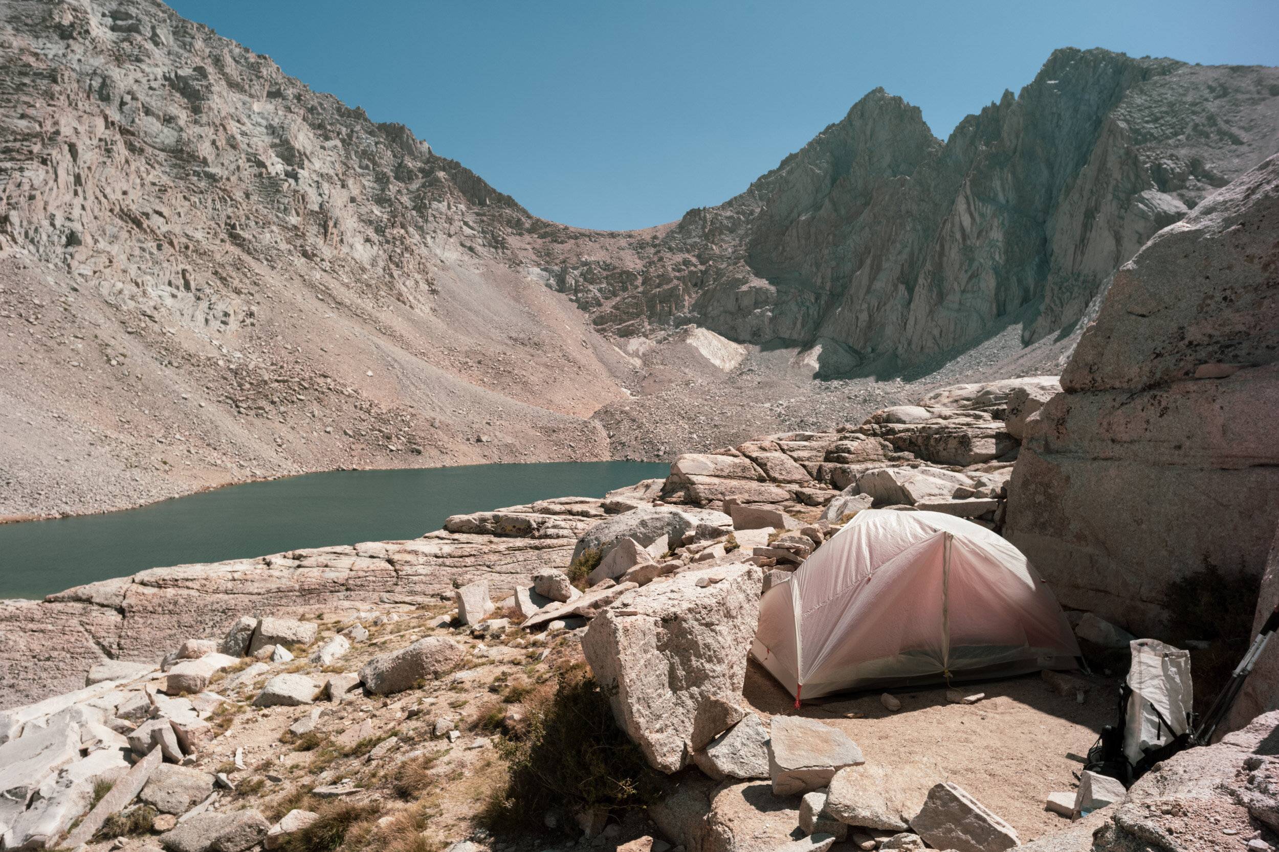
CONSULTATION LAKE CAMP
11,800’

8:02 pm over Consultation Lake

Me so very relived to unwind now that Mark found us a great campsite. Photo by Mark!
Once I found Mark, we scrambled down a maze of rocks to a campsite that had been created next to a large boulder. The site was perfect; it was completely sheltered from the wind by the boulder and a rock wall that had been stacked up 3 feet high, with just enough space for a few tents. It was 8:50pm by the time Jason caught up to us, and we were finally able to start the process of setting up camp. We asked a friendly group camping at the trail to look out for Jonny and Alexia, and I left a very obvious trail marker for them in case they came up after the other campers went to bed (my marker was a hot dog costume laid out and weighted down by rocks. We wondered if our friends were still hiking, or if they had decided to set up their tent lower down the trail. We hoped they’d see the hot dog trail marker and set up there, and we’d reunite the next morning.
By the time we managed to set up our tents, eat a quick meal, and climb into our sleeping bags it was already 10pm. We had discussed a 2am wake-up time, but since we got to sleep so much later than planned, I set my alarm for 3am. Now all I had to do was fall asleep.
Summit Day
I woke up to my alarm at 3am, after probably getting 2 actual hours of sleep. I had spent the first three hours tossing and turning, and needing to pee 3 or 4 times (the combination of altitude, Diamox, and my commitment to hydration had me having to pee nonstop). I was thankful for even 2 hours of sleep, since I’ve struggled through completely sleepless nights at altitude in the past.
Jason, Mark and I made a quick breakfast, and packed up our backpacks with a considerably lighter load for today’s hike to the summit. We hiked with the extra layers we’d need, and just enough food and water, meanwhile everything else could stay behind at camp. The three of us scrambled up to the trail, and started hiking up. My hot dog costume was still laid out on the trail, and there was no sign of Jonny and Alexia, so I took the hot dog with me and hoped we’d catch them at some point on the trail.
We were just a few minutes down below Trail Camp, and from there it didn’t take long to reach the base of the infamous “99 Switchbacks”. I had read that the switchbacks aren’t hard, but that this section of trail is boring and takes forever. I didn’t mind the switchbacks at all, especially at this time of day. We started the 99 switchbacks under the stars, and watched the same view gradually change as we climbed higher and the mountains started to glow as the sun came up. Jason and I looked for a fresh water spring that was supposed to be somewhere around switchback 23 that would be our last chance to fill up water before the summit. We found a trickle of water on the side of the trail, and managed to slowly filter just a liter of sandy water. We had 5.5 liters of water between us to get us up and back here (but being the obsessive hydrator that I am, wished we had more).

5:30 am at the cable section of the 99 Switchbacks. Surreal looking iphone long exposure photo, in reality it was much darker than this.

The sun rising and warming the trail with golden light

Jason near the top of the switchbacks in the glowy morning light
TRAIL CREST
13,600’
Sometime around 7am we made it to Trail Crest, at the top of the 99 Switchbacks. Trail Crest is a ridge that borders Sequoia National Park (if someone hiked this trail with a dog, they can only go this far). This was supposed to be the beginning of “the hard part” of the hike. It was also quite cold and windy up there, with the trail on the Sequoia side being entirely shaded and out of the warmth of the morning sun.

Mark’s sunrise nap spot
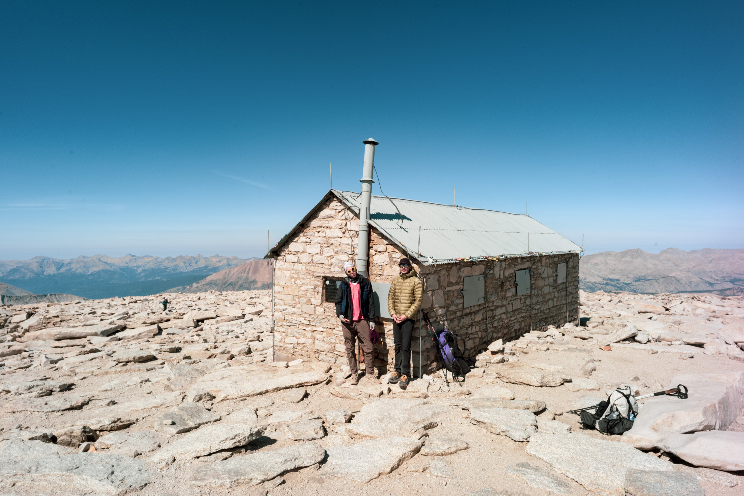
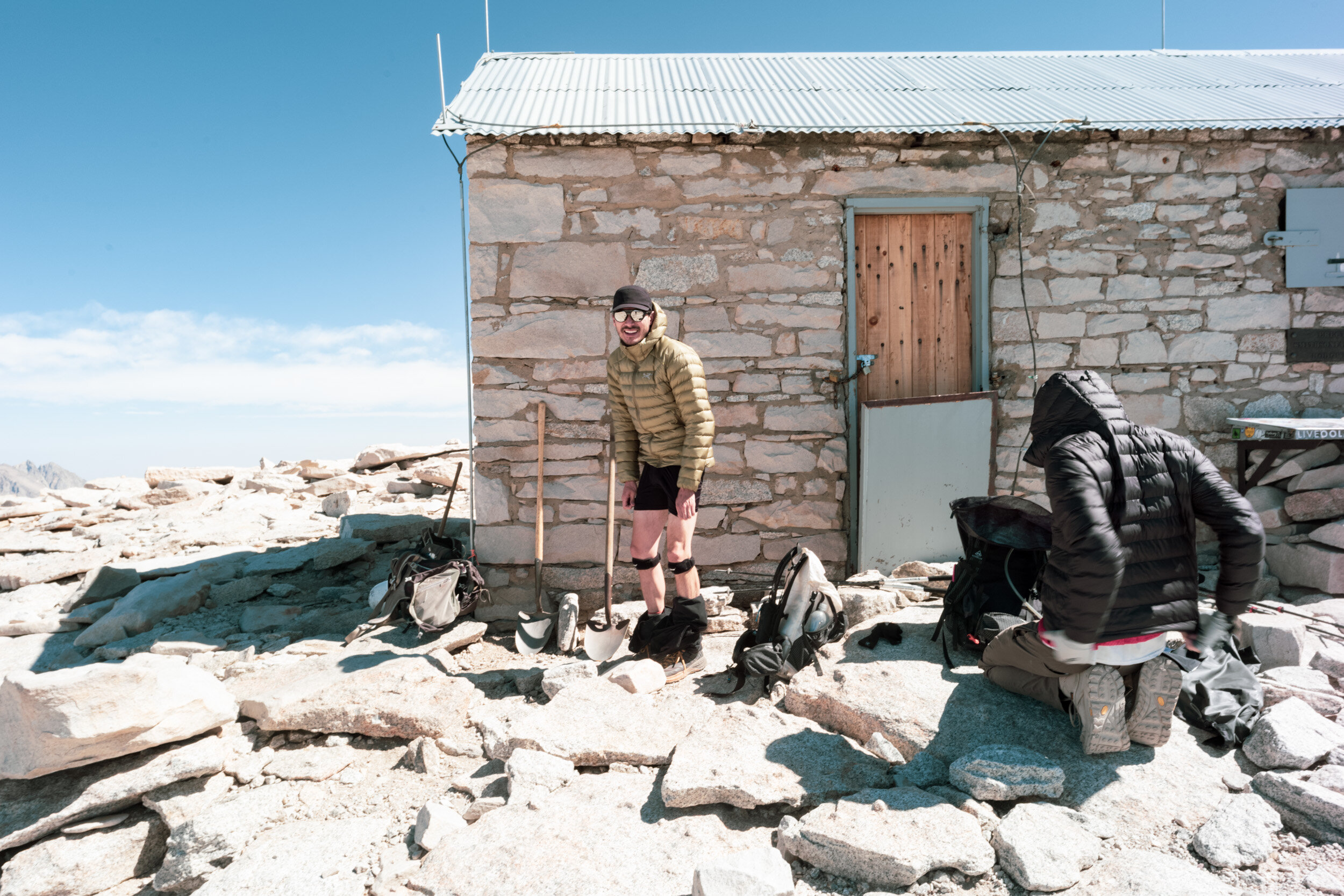
Mark had hiked ahead of us on the switchbacks, and we found him perched on a sunny ledge waiting for us. Mark had again scouted the perfect location; this time a nice spot to rest and eat a snack out of the wind, with a perfectly private little hole to hide in to relieve oneself. Pooping is not allowed (even in catholes) on the trail, and each person is given a “wag bag” to do their business and pack it out. At 13,600’ I gave the wag bag a go (lucky for you Mark was there to document me doing so). I found the process to be surprisingly easy and hygienic.

Private pooping place. Captured by Mark Popovich.

Proud pooper. Wag bags are sized for a rhinoceros to take a dump.

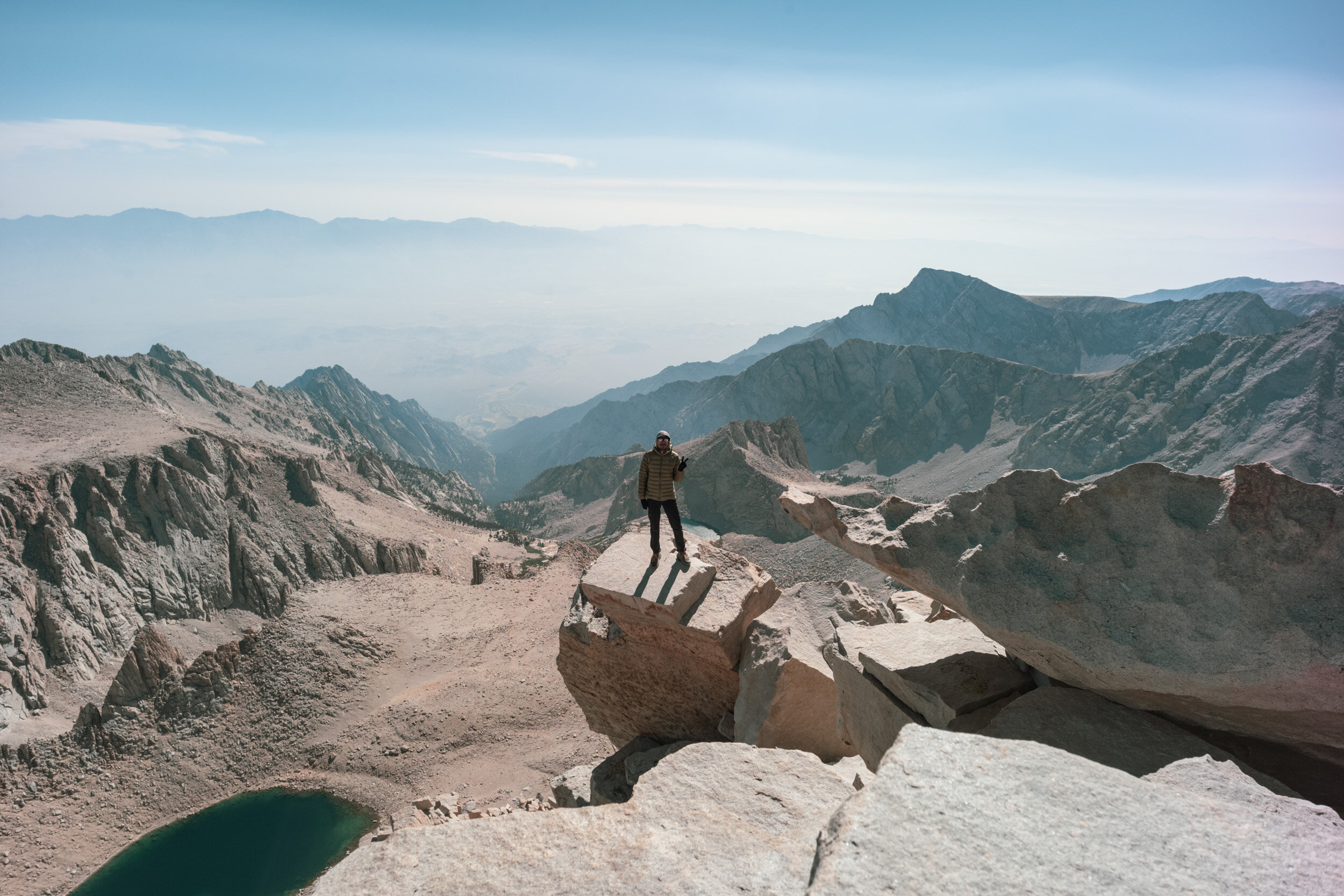
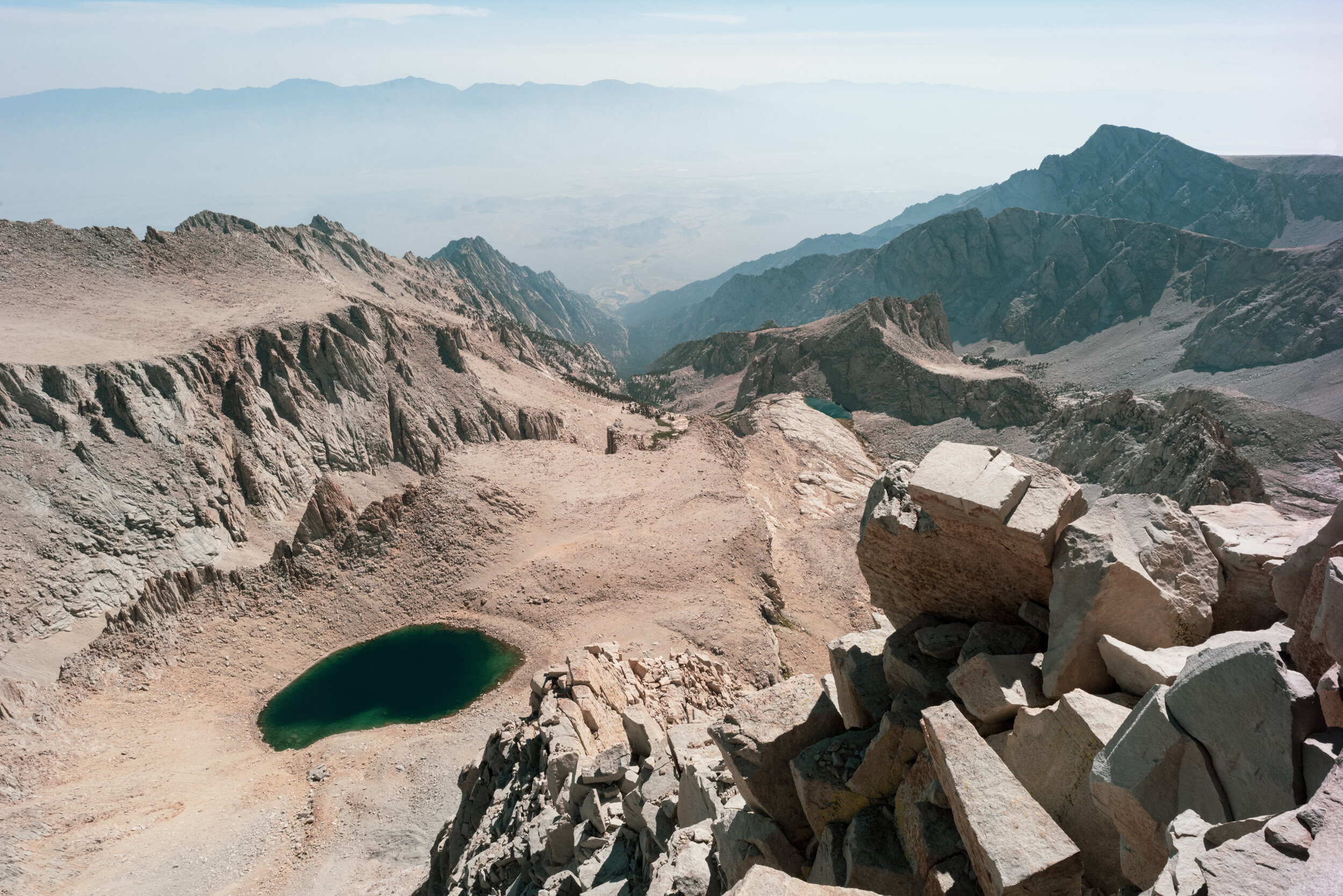
View down into Sequoia National Park

Taking a break at one of the “windows”
The portion of trail between Trail Crest and the Summit was the longest 2 miles I’ve ever hiked. It was freezing cold in the shade, and I was wearing every layer of clothing that I brought with me (a wool base layer top, fleece, a down puffer, and a heavy duty Arc’teryx gore-tex shell, and two pairs of pants). The cold was the worst on our hands, but thankfully I brought both mid-weight glove liners and waterproof glove shells, which did a great job of cutting the wind. Occasionally the trail would cross the “windows”, which would provide phenomenal views to the east, and a sunny place to pause for a moment to thaw. The trail wasn’t ever terribly steep, but zig-zagging along uneven slabs and stones of granite at 14,000’ and above— no single step could be made without conscious and intentional effort and breathing. Like the evening before, the challenge felt more mental than physical, and I was thankful to have the daylight on our side so I could take my time today.
Difficulty aside, this stretch of the trail was absolutely gorgeous, like a landscape from another planet. I wish I had snapped more pictures, but because I was so focused on putting one foot in front of the other, I didn’t use my camera as much as I ought to have.
THE SUMMIT!!!

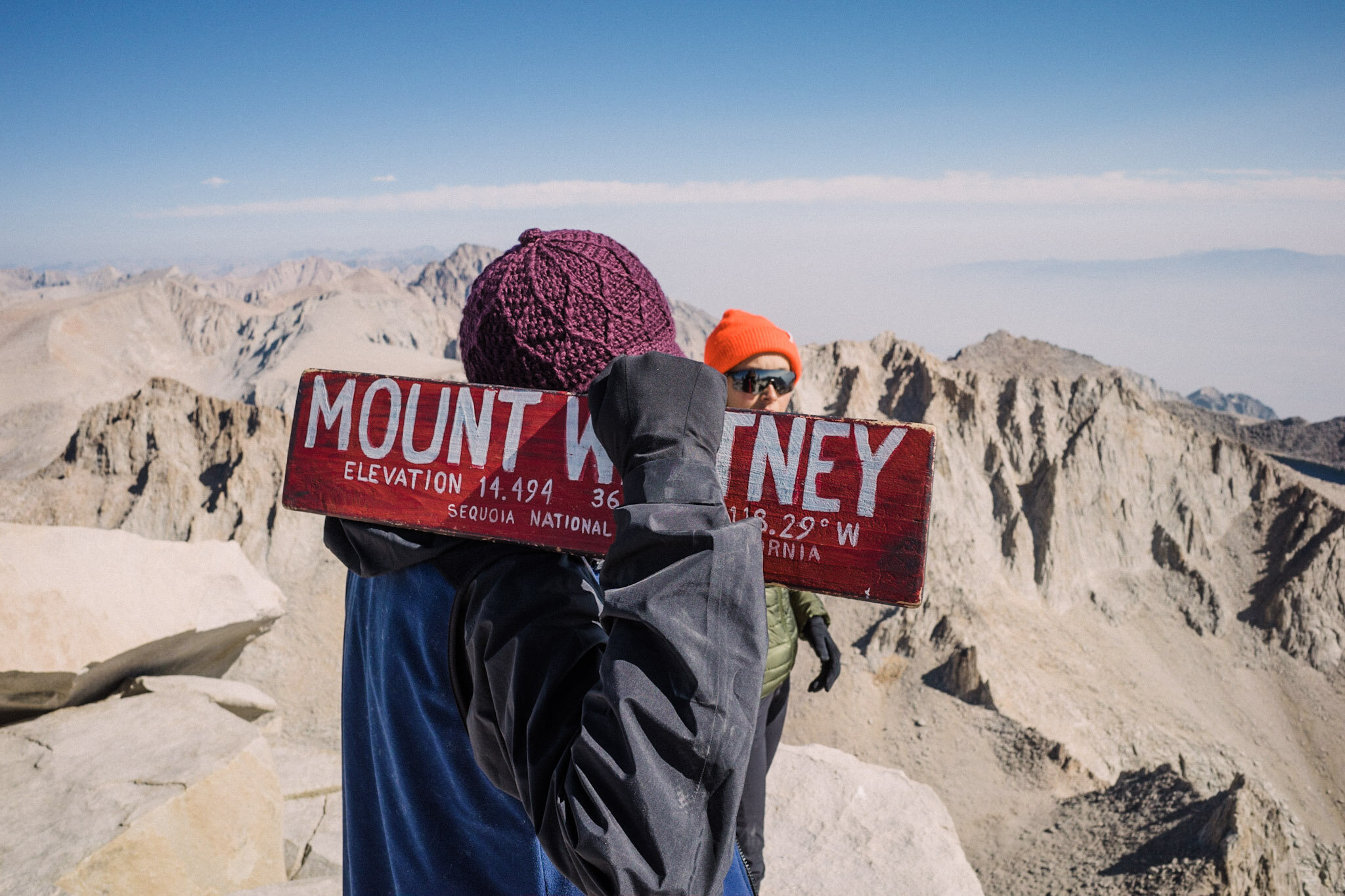
I had heard that the last mile coming up the back of Mt. Whitney is the hardest, with a few false summits… so I had accepted that I was gonna be coming up that last stretch for a long time. Now that Jason and I were above 14,000’, I was having to pause constantly to let my body re-oxygenate. I had stopped for a quick sit when Jason, just a few steps ahead of me called out “Don’t stop! Look right there!”. Just a few more steps and I could see the summit hut! At around 9:30 am we had made it to the top!
At the summit there’s clear cell reception, and up there you’ll see people taking the opportunity to FaceTime their friends and family. As soon as reception kicked in, I received a text message from Jonny from midnight the previous night. He said that after we last saw them, he started throwing up (probably from altitude sickness), and so he and Alexia had decided to turn around and hike all the way back out. It was a bummer to be at the summit without them, but at least now we knew where they were and that they were fine.
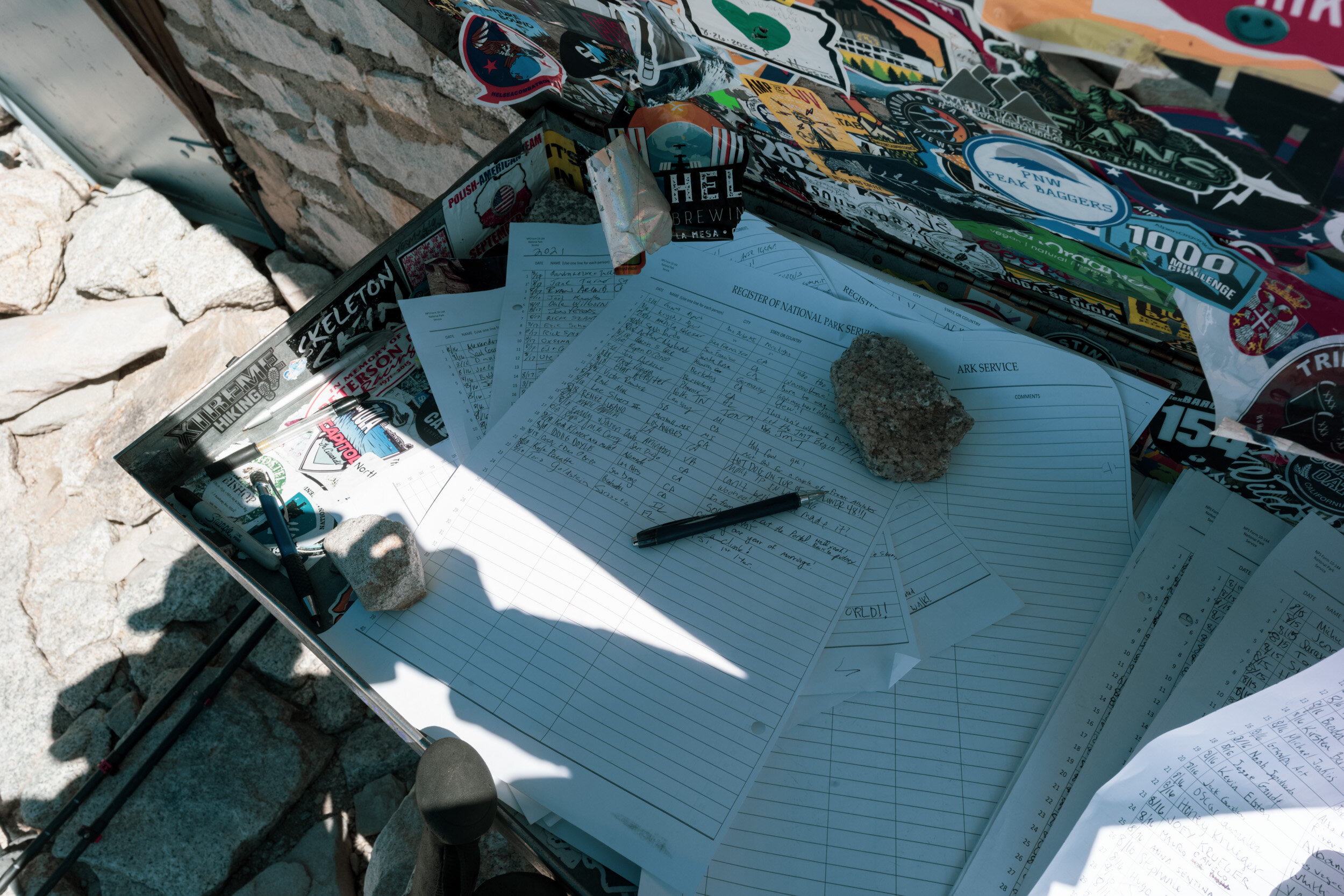
The weather at the summit was absolutely perfect. The sun was out (not a single cloud to cause concern about a thunderstorm), it was cool, and the wind was completely gone. Mark was up top (he already got in another nap while waiting for us of course). We spent the next hour signing the trail register, FaceTiming our moms, admiring the view, and posing for obligatory Mt. Whitney sign selfies (there were 5 or 6 different handmade signs at the summit to pose with). Jason also slipped in a casual marriage proposal (yes, for real). Jason had followed me behind a small boulder that I had fled to as the only somewhat suitable place to go pee, and took me by complete surprise with a very sincere proposal (meanwhile we were standing over my puddle of pee… he said it was the only private opportunity he saw).

Moments after Jason proposed, Mark excitedly rushed over to photograph the occasion.

A ring Jason made from the wire of our Whitney hiking permit tag.
THE LONG WAY DOWN
With all of the sunshine and happy times to be had at the summit, we almost forgot that there was still 11 more miles to hike to get back down the mountain that day! After over an hour at the summit, we started to retrace our steps back down the trail. Going down was exponentially easier than going up had been, and I could finally walk at a quick pace. BUT, the trail is not entirely downhill before Trail Crest— even as the elevation dropped from 14,500’ to the 13,000s, my fatigue was starting to set it— and any bit of climbing uphill felt absolutely grueling. Those views though! Both sides of the ridge were now on full display, lit by the sun.
Once we made it back to Trail Crest, it was pretty easy hiking. Yes there were 99 switchbacks to endure, but they’re a more consistent grade and terrain. Jason and I were thirsty and low on water with the sun was blazing… but after 70 or so switchbacks we’d be back to that last spring where we could filter and refill.
The switchbacks came and went, and before we knew it we were hiking past the picturesque pond at Trail Camp. Just a few minutes further down the trail was our campsite, where we were reunited once again with Mark at 2:30. Mark, being the fast hiker he is, made it back down to camp with enough time to pull his sleeping pad into the shade of a large boulder to take another nice long nap (so that’s what… 3 naps for Mark, zero for us). I only allowed myself a quick lie down and stretch before repacking my pack for the final stretch back down. We were packed and back on the trail at 3:30.


Coming down the cables section of the switchbacks where we had been before sunrise that morning

The pond at Trail Camp
Back to our tent above Consultation Lake

A quick lay down before packing everything back into my pack

Me capturing Consultation Lake, captured by Mark

Mirror Lake down below

Back to a very calm Mirror Lake
It was amazing to see everything in the daylight that we had missed on the way up. In a rush to beat the wind and darkness to camp, we had been unable to fully appreciate the scenery above Mirror Lake.
I don’t recall a lot of the individual details of the trail below Mirror Lake. By then we had already done 12 miles, and with just 3 more miles to go, we were exhausted and increasingly eager to get out of our boots and into our comfy Crocs at the car. Overall I felt tired but pretty decent, only the bottoms of my feet were feeling sore.
Some while before the 7:30 sunset, we made it back to the trailhead. Our return was celebrated by a final backpack weighing (19lbs!), and farewell to my poop-filled wag bag into the biohazard human waste trash bin!

5 lbs lighter than when I started!

Bye bye poo poo

Looking back to Mt. Whitney at dusk
Boots off and Crocs on, Jason and I made the steep drive down Whitney Portal Road into Lone Pine. In town we ate nachos from a taco truck, beer from the grocery store, and then attempted to settle into a cute old motel. Initially we checked into The Portal Motel.. but despite being dead tired, we were so disappointed with the room that we got a refund, removed our things, and went across the street to the Dow Villa Motel. The Dow Villa was comfy, clean, and had a functioning bathtub and a hot tub(!!!) which we utilized the next morning.
Mt. Whitney was an incredible experience, and there’s not much I would have done differently (just left earlier on day one!). I had underestimated how prepared I actually was for the hike, and now having completed it, I realize that there’s so much that I can accomplish if I work hard, train hard, and stop doubting myself! And great company and companionship along the way is huge. 💖

Jason poolside at the Dow Villa Motel (Mt. Whitney in the distance)

Yes, Please

Selfie of us in the hot tub, Jason pointing to the peak we just climbed